Jayawijaya Peak, a roaring mountain

>> Jumat, 25 Desember 2009


Jayawijaya Peak, a roaring mountain is permanently covered with snow, despite its location on the equator. We'll quite never forget meeting an awful-looking Dani, bearing the tusk of a wild pig at the tip of his nose. Despite their groovy looks, these are quite gentle people, shaking your hand politely and always having time for a small chat.

Likewise, women don't wear terribly much clothes. Just a skirt, entirely made of natural materials will do. It is the women's duty to carry out the heavy work on the fields. Observe the nuke, typical cloak-like bark string bags, carried half over the head. Heavily loaded with cabbage, sweet potatoes and sago, they resemble a blanket. A woman covered in river mud, is in grief. A less innocent way to show mourning, is finger amputation, a fate that only women will befall. Despite serious efforts of the government to halt this practice, they continue being reported occasionally.

The Baliem Valley remains one of the most fascinating places on the planet, where man may confront it its prehistoric past. But even in the remotest of area. Civilization is seeping through and will not be kept at bay. Maybe the time is right to visit the wild beauty of the Baliem Valley and its remarkable people.

http://www.indonesia-tourism.com/east-papua/baliem_valley.html

Read more...

Pangandaran Beach

Small mainland peninsula with a national park with beaches and stunning scenery to rival the beaches of Bali on the south coast of Java. Pangandaran is one of Java's best-kept secrets as far as international tourists are concerned, but has been extremely popular with locals for along, long time. A small fishing town, it possesses one of Java's finest beaches and Pangandaran Nature Reserve teems with wild buffalo, barking deer and monkeys. The people are very friendly, this combined with the idealize surroundings make this a great place to spend a few days relaxing island-style. Pangandaran is halfway between Bandung and Yogya, about 5 hours by bus from Bandung and 8 hours from Jakarta.

This is the second beach resort area on the Indian Ocean after Pelabuhan Ratu. The site is 223 from Bandung and 400km from Jakarta. The trip by car or bus is recommendable because the road conditions are good. However, if we prefer to take the train, get into Bandung-Yogyakarta Express train and get off at the Banjar railroad station about 4 hours later. From here it will be another 50 km by bus to Pangandaran. The beach is called Penanjung, where most of the cottages and hotels are located, however, of modest ratings. Nothing luxurious should be expected. Pangandaran is especially of interest to nature lovers, as there is a wildlife reserve in the vicinity where wild birds and other indigenous animals live about freely to be enjoyed by visitors. In Pangandaran visitors will like fine white beaches, blue ocean and fine seafood. Twelve kilometers before arriving at Pangandaran visitors will see a huge rock on the beach, which is called Karang Nini.

Another place of special interest for nature lovers is a forest Conservation Park, close to the camping ground, which has basic facilities suitable for the younger set. Somewhat further out, west of Pangandaran, driving 23 km on the way to Parigi, lays Batu Hiu, meaning Shark's Rock, a coastal rock that has the shark shape.

http://www.indonesia-tourism.com/west-java/pangandaran-beach.html

Read more...

KIng Sate

Raja Sate BBQ & Asian Resto
Jl. Boulevard No. 39
Manado
Phone: 0431 846679
Email: RajaSateResto@yahoo.com

No, there is no king that I met but... I was pleasantly surprised (maybe that happens too easily) when I brought my 2 kids to another new restaurant that opened in Manado. Living in a small town can often play tricks on your mind but this wasn’t a trick - the food was tasty, service quick and the atmosphere was pleasant both during the day and evening hours. Raja Sate, located at #39 Jl. Piere Tendean (boulevard), has a full variety of foods to choose from soups, sate, vegetables and even Ayam Kampung (local chicken not from the chicken farm). We arrived at 7:30 PM on a weekday and we were immediately seated, I chose a seat under a fan but you can find less breezy places if you like. The menu came immediately and we were actually served within 17 minutes of ordering - a new record for non fast-food restaurants. Drinks came without reminding the waitress well before the meals! My favorite is the goat sate which is served on its own little hibachi with accompaniments of Kangkung Cha (local spinach but better) and white rice served on a top of a banana leaf with a plate of course. We finished our meals, we thought but then the waitress graciously said sir, "please wait, here is your fruit". We finished our fruit with vows to return - we did and we were not disappointed!

Jeremy Barnes

Read more...

Bunaken National Park

The Bunaken National Marine Park was formally established in 1991 and is among the first of Indonesia's growing system of marine parks. The park covers a total surface area of 89,065 hectares, 97% of which is overlain by sparkling clear, warm tropical water. The remaining 3% of the park is terrestrial, including the five islands of Bunaken, Manado Tua, Mantehage, Nain and Siladen. Although each of these islands has a special character, it is the aquatic ecosystem that attracts most naturalists.

The waters of Bunaken National Marine Park are extremely deep (1566 m in Manado Bay), clear (up to 35-40 m visibility), refreshing in temperature (27-29 C) and harbor some of the highest levels of biodiversity in the world. Pick any of group of interest - corals, fish, echinoderms or sponges - and the number of families, genera or species is bound to be astonishingly high. For example, 7 of the 8 species of giant clams that occur in the world, occur in Bunaken. The park has around 70 genera of corals; compare this to a mere 10 in Hawaii. Although the exact number of fish species is unknown, it may be slightly higher than in the Philippines, where 2,500 species, or nearly 70% of all fish species known to the Indo-western Pacific, are found.

Oceanic currents may explain, in part, why Bunaken National Marine Park is such a treasure trove of biodiversity. Northeasternly currents generally sweep through the park but abundant counter currents and gyros related to lunar cycles are believed to be a trap for free swimming larvae. This is particularly true on the south side of the crescent-shaped Bunaken Island, lying in the heart of the park. A snorkler or diver in the vicinity of Lekuan or Fukui may spot over 33 species of butterfly fish and numerous types of groupers, damsels, wrasses and gobies. The gobies, smallish fish with bulging eyes and modified fins that allow them to attach to hard surfaces, are the most diverse but least known group of fish in the park.

Biologists believe that the abundance of hard corals is crucial in maintaining the high levels of diversity in the park. Hard corals are the architects of the reefs, without them, numerous marine organisms would be homeless and hungry. Many species of fish are closely associated with particular types of corals (folious, branching, massives, etc.) for shelter and egg-laying. Others, like the enormous Bumphead Parrotfish, Balbometopon muricatum, are "coralivores" and depend on hard corals for their sustenance. Bony mouth parts fused into an impressive "beak" allow these gregarious fish to crunch corals like roasted peanuts.

Some 20,000 people live on the natural resources of Bunaken National Marine Park. Although there are inevitable conflicts between resource protection and use by people, the Indonesian government is taking a fairly unusual and pragmatic approach to park management. The idea is to promote wise resource use while preventing overexploitation. Local communities, government officials, dive resort operators, local nature groups, tourists and scientists have played an active role in developing exclusive zones for diving, wood collection, fishing and other forms of utilization. Bunaken Marine Park has become an important example of how Sulawesi, and the rest of Indonesia, can work to protect its natural resources.

http://www.north-sulawesi.org/bunaken.html

Read more...

MOUNT BROMO


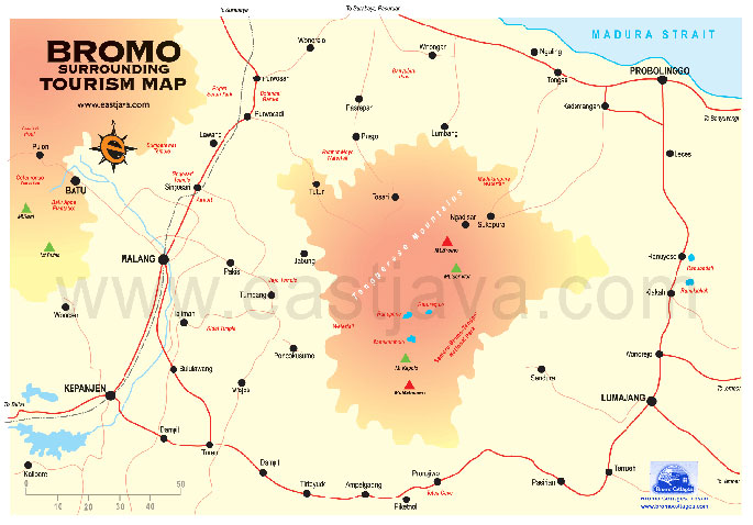
Bromo have known by all of visitor of the worlds. They come to Bromo to watch the sunrise. The visitor also can look down to the crater that full of its smoke, and feel the cold of the air, is probably could only be done in Bromo. Our eyes will also completed by the sea of sand that the way to reach Bromo’s peak. The main gate to the sea of sand and mount Bromo is through Cemorolawang. This is the most crowded visiting area, espesially on holidays. There are many kinds activities that could be carried on this area such as; Camping, watching the scenery, horse riding to sea of sand or walking.

To get to the peak Bromo with its largely open crater, which belch of smoke expelling from its bottom. Mount Bromo has settled by Tenggerese for about thousands years. They who are good of God follower and always do their custom strickly, has historical relationship with Majapahit. The Antropologist from our country or other country are interesting to do some research, because the Tenggerese are strickly in keeping custom for centuries, without influenced by world’s change. So there so many version of the unique of Tenggerese in

Probolinggo, it can be in the forth of tale, folktale, serat and kidung, legend and science report.As a good follower of God, which have Hinduism belief, they have many kinds of traditional ceremony such as; marriage ceremony, Entas-entas, Wilujengan Karo, Wilujengan Kapat, Wilujengan Kapitu, Wilujengan Kawolu, Wilujengan Kasanga, Wilujengan Kasada. Those of ceremony are lead by a person who supposed to have a magic power to make a communication with powerful things (roh halus) that called ‘Dukun’. However, the ancestor of Tenggerese are married couple named Rara Anteng (Teng) and Jaka Seger (Ger). The combination of the two syllables were than abbreviated as Tengger. They had not child for some years, then they decided to had a meditation. They orayed to God in order that he granted their wish. One day there is aa misterious voice that said: that one day when Sang Hyang Widhi (God) wanted to give them children, one of them had to sacrifice to Bromo Crater (Bromo Mountain).

Many days later, Rara Anteng birth her first son named Tumenggung Klewung, then followed by other children and they had 25 children. Firstly, they didn’t want to sacrifice one of their children, but they had a sign from Bromo that they must to keep the promise. Finally, their last son named Raden Kusuma had take by Bromo crater as a requirement for Dewata Sang Hyang Agung (God). Next, the misterious voice of Raden Kusuma gave an order to provide half of the harvest to be sent to Raden Kusuma in Bromo Crater every Full Moon at 14th, Kasada month. Because of that, every full moon at 14th in Kasada Month, people sent Raden Kusuma many kinds of harvest in Bromo mountain. That ceremony, which called “Yadnya Kasada” becomes a tradition (custom) that held up to know.

http://www.eastjava.com/tourism/probolinggo/bromo.html

Read more...

Pasuruan Tourism

Pasuruan regency is one of tourism place in East Java, which has potency of nature, culture and tourism attraction that be able to expose the completely tourism enchantment (The East Java Natural Enchantment).

Pasuruan is one of tourism object in East Java that has glamour nature and marvelous culture, such as panorama of mount Bromo seen from Penanjakan, or the fascinating of Tretes tourism area, the amazing of agro tourism area in Tutur, recreation area at Prigen, which presenting multifarious animals in Safari Park Indonesia II, the center of recreation and entertainment amusement of Taman Dayu, Fina Golf and there are still a lot of tourism object which is interesting to be visited.
Pasuruan regency is located 60 km south of Surabaya. Beside its tourism object, Pasuruan also has industrial area and crafting which has its own characteristic, such as; small industry and crafting of embroidery in Beji, Bangil, gempol, and Keraton. Crafting of wood in Prigen and Karangrejo. Crafting of accesories in Bangil and Gempol and also crafting of iron in Gempol and Poh Jentrek.

TAMAN SAFARI INDONESIA II
This tourism object is located at Jatiarjo village Prigen distric. This natural preserve is the branch of Cisarua - Bogor natural preserve. As the natural wild life, preserve Taman Safari Indonesia collects various wild animals. This wildlife preserve is 295 hectares, the wild animal such as : lion tiger, wild buffalo, komodo, rhinaceros, bison that live in open area. Lies at the slope of Mt. Arjuno 800 – 1.500-meter sea level cover 340 ha and divided three zones. Wild life zone, place for visitor observing a natural wild life. Attraction zone for performing education through entertainment attractions. Each Sunday we can see that circus of Taman Safari Indonesia Jl. Prigen. Baby zoo zone place for visitor to getting photos and closing to the baby animals. Taman Safari surrounded by the beautiful panorama and fresh atmosphere with temperature 24-25o C, it also has supporting facilities such as; recreational park for children. This location is easy to be reached. It take only 1 hours from Surabaya or Malang.

COBAN BAUNG WATERFALL
The waterfall is 100 meters high as one of natural attractions. It is located at Purwodadi village exactly in the east of Purwodadi Botanical garden. It has surrounded by a protected forest with various animals like monkey, deer, etc. It has provided camping ground.

APPLE AGRO TOURISM
The agro tourism is located at Andonosari village, Tutur subdistrict. It's about 40 km from Pasuruan city. The visitor can be relax and go around the Apple plantation.
If we want to pick some Apples by ourselves and eat them as many as we want, we have to pay a admission fee at first. The agro tourism covers an area about 1100 hectares and the apples which are planted consist of Manalagi, Rhomebeauty, Anna and Wanle.

KAKEK BODO WATERFALL
It is located at Tretes and belongs to Pasuruan forest range unit. It can be accessible from Surabaya for about 45 minutes drive. Kakek Bodo is an esthatic Forest lines are located at the Pasuruan Forest District, Forest Ranger unit of the west Lawang, Sub Forest Ranger of Prigen. It's about 35 km from Pasuruan. This recreational forest has surrounded by pine forest and other trees such as, Akasia (acacia decurrens). Kaliandra (Calliandra Calathyrsus) and Mahoni (Swientenia Macraphylla). In this area we can find the kakek Bodo Waterfall 40 meters high, the esthetic forest cross, recreational park for children, and the grave of Kakek Bodo.

SIEN ORCHID
Sien Orchid Garden collects many kinds of orchids and decorative plants, which is located on the way between Pandaan – Tretes. The visitor can see the beauty of orchids and buy them as souvenirs. In this garden is cultivated many kinds of orchid, which are preserved and for collection.

SKI LOT (MUD SURFING)
Ski Lot is the traditional attraction of Lekok fisherman. It is usually held annually on the seventh day of Idul Fitri (lebaran ketupat) in a field with full of mud. Ski Lot is an unique attraction because the competitor must catch a crab, a lele fish and an eel by surf on the mud. Not only men, but also women follow the competition. At the same time at Lekok beach, it is also held row race and decorative.

Read more...

Borneo

>> Rabu, 02 Desember 2009


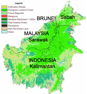
Borneo is surrounded by the South China Sea to the north and northwest, the Sulu Sea to the northeast, the Celebes Sea and the Makassar Strait to the east and the Java Sea and Karimata Strait to the south. It has an area of 743,330 square kilometres (287,000 sq mi).

To the west of Borneo are the Malay Peninsula and Sumatra. To the south is Java. To the east is the island of Sulawesi (Celebes). To the northeast is the Philippines.

Borneo's highest point is Mount Kinabalu in Sabah, Malaysia, with an elevation of 4,095 m (13,440 ft) above sea level. This makes it the world's third highest island.

The largest river systems are the Kapuas River, with approximately 1,143 km (710 mi) the longest river in Indonesia, the Rajang River in Sarawak with some 562.5 km (349.5 mi) the longest river in Malaysia, the Barito River about 880 km (550 mi) long and the Mahakam River about 980 km (610 mi) long.

Borneo is also known for its extensive cave systems. Clearwater Cave has one of the world's longest underground rivers. Deer Cave, thought to be the largest cave passage in the world, is home to over three million bats and guano accumulated to over 100 metres (330 ft) high.

http://en.wikipedia.org/wiki/Borneo

Read more...

HISTORY OF BANGKA ISLAND


During the 17th Century, Hindu people from Siantan and Johor of Malaysia inhabited Bangka Island. Subsequently it was occupied by Sriwijaya Kingdom (686 AD) who was written "Wangka" which means "Tin" on a stone, that's why Bangka Island is also called "Tin Island", the stone was found in the Western part of the island, near Kota Kapur, now the stone still can be seen at the National Museum in Jakarta.

Bangka was ceded to Britain by sultan of Palembang in 1812, but in 1814 it was exchanged with the Dutch for Cochin in India. The Japanese from 1942 to 1945 occupied the island. It became part of Indonesia independent in 1949. The island, together with neighboring Belitung, was formerly part of South Sumatra province, but in 2000 the two islands became the new province of Bangka-Belitung. Bangka is famous for two other events; the Banka Island Massacre in WWII by the Japanese of Australian Nurses and as reputedly the setting for the book "Lord Jim" by Joseph Conrad. Bangka is also home to a number of Indonesians communist that has been under house arrest since the 1960's and are not permitted to leave the island.


http://www.indonesia-tourism.com/bangka-belitung/history.html

Read more...

  © Blogger template Simple n' Sweet by Ourblogtemplates.com 2009

Back to TOP